
History of Preston 1900 to now
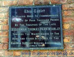
Near Preston Railway Station is a tablet on a wall.
1909 - 1914
An Ordnance Survey map of Central Preston in 1909 is available although it says 1912 Edition inside. On this map the items that stand out are The Yard Works across from the Prison and New Preston and Alliance Mills on New Hall Lane. Quite a few gasworks and mill reservoirs. Features that have disappeared such as the houses near the centre of town and the narrow streets, lots of terraced houses. The tramway up Deepdale Road, Ribbleton Lane, New Hall Lane, Friargate, Fishergate and North Road. The map shows the end of the Lancaster Canal at Maudland with the star shaped railway track where the coal yards met the canal. The maps are available from Alan Godfrey Maps, Consett. www.alangodfreymaps.co.uk.
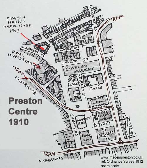
On the sketch below of Preston Town Centre from the Ordnance Survey map of 1912 the most notable features are the gap between the County Sessions building and the police station in Earl Street. This is where the Town Hall now stands after it burnt down. Also the Starch Houses are shown, these were knocked down in 1913 sand replaced by Starchhouse Square which was a bus and coach terminal. Also the tram lines were a big feature.
Just after the turn of the century the County Court Building was built next to the Harris Library and has a similar finish but with ornate towers.
Engineering was developing in the early part of this time and Strand Road was developing next to the docks.
Local Family Photos
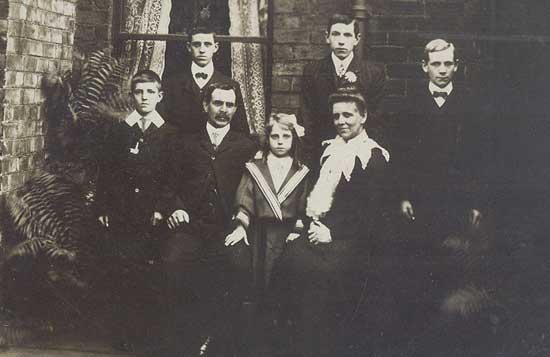
Grandfather and Gt Grandfather 1905 or there-about. Mothers side. 5 children, one lost at birth. All railway people.
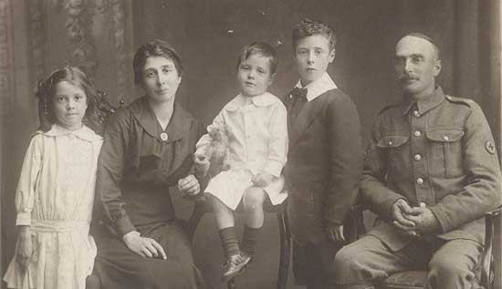
Grandfather and grandmother with father, the small one, in 1918 or there-about. One child lost to the flu epidemic, another to come. English Electric and Docks.
First World War 1914 -18
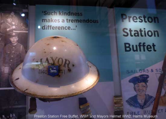
During World War 1 people came from all over Britain by train passing through Preston station very hungry. Preston being on the main route from Scotland.. A free buffet was set up with 400 female volunteers and they served over 3 million soldiers.
1918 - 1940
Cinemas were being built on Church Street with the Empire, Palladium, New Victoria, Ritz in a cluster.
Preston was relatively fortunate as it had a fairly diversified employment base. Lancashire cotton was a declining force from the first world war but Preston had automobiles at Leyland and the rubber factory. It also had trams, trains and later aircraft at English Electric. The docks had a wide range of trade including bananas, wood pulp and oil. Modern fabric such as Rayon was produced at a newly built factory. There was also Ribble Paper Mills and Atkinson's Vehicles at Walton Le Dale. Preston was and still is the administrative centre of Lancashire which at the time included Manchester and Liverpool.
Voting rights were extended to a total of 18m people in 1918 including 5m more males and 8m more females. In Preston Edith Rigby is remembered by a Blue Plaque in Winckley Square primarily for her women's right to vote activity although she founded a school as well as causing an explosion at the Liverpool Corn Exchange and burnt down the home of Lord Leverhulme at Rivington.
At the General Election in 1918 Preston returned a Coalition Conservative MP and a Labour MP. Four candidates stood and there was only around 1000 votes difference between the winner and the fourth.
1939 Preston Park School Magazine
My mother and her sister attended the Park Grammar School for Girls. Here is an extract from the annual magazine that gives a feel for the social and historic context of this turbulent time. The magazine was published in May 1939, just before the declaration of war with Germany in September. However in March 1939 Germany invaded Czechoslovakia and the Spanish Civil War had been underway since 1936 - another part of the Park School magazine thanks the girls for collecting clothes for Czech and Spanish refugees.
At this time my mother had a pen friend in Belgium who was later driven from her home by German occupation, I have a personal letter from her relating the story 5 years after the event and apologising for not writing (I thought it was on the website but can't find it).
Second World War
January 1940 was one of the worst winters known in the UK. The railway was closed in Preston for a long period.
Industry in Preston was adapted to wartime production. English Electric, Dick Kerr's as it was known, in Strand Road became a 'shadow' aircraft manufacturing plant making thousands of bombers with a new plant being built at Samlesbury. Leyland Motors started producing tanks and a road called Centurion Way was built. Despite this, not much bombing occurred to Preston. Even though Preston must have been enroute to Barrow which got a lot more due to its shipbuilding. A bomb dropped on Ward Street in Lostock Hall killing several people and many theories exist about why one bomb there.
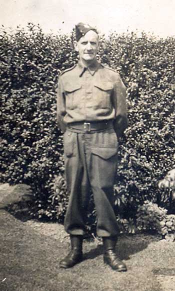
The Home Guard were recruited from older men. Here's my Granddad.
Story of a Beckton Boy Evacuated to Preston
".....That dark night in 1939, we had crossed from Manchester to Preston by branch line and then by taxi to Penwortham. I must have slept on the second train. There was snow on the ground when we arrived. Mother asked the cab-driver to sound his hooter. A squeeze or two of the big rubber bulb brought Granny downstairs to open the front-door and let Queenie the bull-mastiff out onto the snow-covered lawn. Somehow, in various ways, we managed to get to bed. My brothers and I, except for the baby, slept on a flimsy spare mattress hurriedly laid over boxes and tea-chests in the dressing room outside the bathroom. We were amused later to see an enamel plate saying 'LAVATORY' on the door to our room.
The snow and cold continued for weeks. Snowdrifts blocked the rail line after our hurried journey north. In Grandpa?s orchard, snow lay over a foot deep. I could only go to see him milk the goats by stepping in my mother?s footprints while she held my younger brother. My father walked daily to Penwortham station to know when the main-line was open for trains to and from London. For a while, he was unable to return to his job at Bishopsgate Goods Station. Penwortham station, on the line to Southport, had wooden platforms.
LIFE IN PENWORTHAM
Our grand-parents in Lancashire had only oil-lamps and candles for lighting and the cooking was done on the open coal-fire. I remember the slipper-irons heated in the fire for ironing clothes. No ? we didn't have warming pans ? the beds were cold. When grandpa was ill in bed, two of us boys had to hold a sheet of newspaper across the opening to draw his coal-fire into a blaze. He was cold through sitting up to shoot birds through the open window. Granny had to go out to pick up shot birds from the snow. They were lined up along the kitchen dresser. Grandpa had several guns, including a big punt gun used in his younger days, wild-fowling down the Ribble Estuary......"
'WW2 People's War is an online archive of wartime memories contributed by members of the public and gathered by the BBC. The archive can be found at bbc.co.uk/ww2peopleswar'
We lived through World War II by Philip AG Kelly. (Nice story, had forgotten about putting paper over the fire front to make it draw better. The best trick being to let the paper set on fire, stuff it up the chimney and run outside in the hope it would come flying out of the top. Boys will be boys. Chimney fires caused occasional interest and the fire brigade always made sure the that the culprits house was filled with water.)
1947
In 1947 the magnificent Gothic Public Hall, built to display Prestons 19th Century industrial wealth and designed by architect Sir George Gilbert Scott burnt down and was left derelict until 1962 when Crystal House was built.
There is a lesson that these buildings in Preston are precious and the wealth that built them is unlikely to come back. We need to look after them or the result will be a spiral of decline.
1950's
Life in 1950's Preston started with food rationing. Buildings appeared black from coal dust. At the same time engineering companies were booming.
English Electric was building the Canberra and later the Lightning aircraft. Locomotive engines and the Deltic prototype was built in Preston. Cotton mills were still employing large numbers of people. Printing presses were being produced. Preston Docks was busy building trade in wood pulp and bananas. Around the area Leyland Motors was producing over 1000 buses a year and dominating bus production in the UK as well as exporting their PD1 and PD2 rear platform buses as well as lorries. At Leyland Rubber and Leyland Paint works were in full swing. Ribble Paper Mills were producing paper and Atkinsons produced lorries in Walton Le Dale. These bigger factories were supported by a host of smaller companies such as forges, transport and food suppliers.
Yet the opening of world trade restrictions was beginning to tell as markets for cotton and former British Empire markets began to be entered by foreign manufacturers. As the markets declined for UK goods, workers were demanding better wages and conditions.
Housing in Preston was still poor in the early 50s. Terraced houses often didn't have a bathroom and the toilets were outside. Throughout the 50s houses were having bathrooms fitted although the toilets remained outside. Television was rare in the early 50s and listening to the BBC Light Service or Home Service on a 2 feet high radio with crackling interference from passing traffic was the norm. We lived next to a bus stop and the conductor's bell sounded on our radio and that was followed by next doors dog barking and chasing the bus.
Preston being on the West Coast Main Line had several crack express trains bearing large faceplates such as 'The Caledonian', 'The Royal Scot', 'The Mid-day Scot' pulled by the powerful Coronation Class locomotives. The LMS, as was, named its trains and locos after royalty, whereas the LNER named its trains after ducks and horses. Rail travel to Blackpool was at a peak and well over two hundred 'special' trains from all over Britain would pass through during a summer weekend, mainly Saturday morning. What joy for a train spotter.
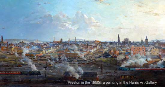
The painting of Preston in the 1950s below hangs in the Harris Art Gallery. An excellent work capturing the railway, factory chimneys, church spires, hills in the background.
In 1958 the Preston By Pass was opened, the first motorway, and what excitement that was. We didn't have a car so a neighbour taking us on a ride on the new motorway was a big thrill, after reaching over 70mph it seemed like we weren't moving at all when we came off the motorway. The huge traffic jams in Preston caused by Blackpool Illuminations and trips to the Lakes could now go round Preston but would still end up on Blackpool Road.
Like all the northern towns Preston closed for 2 weeks in summer. Preston Wakes Week was usually the second half of July. Everyone went to Blackpool or similar and all the factories, shops and services in Preston closed. To stay in town meant a time of empty streets.
Fridges were rare. We had a meatsafe which was a cabinet with a mesh front. Electricals were a bit dicey as well. It's amazing anyone survived.
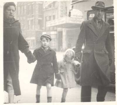
Here's us in Church Street in the 1950's, a photographer was often standing there or outside the Ribble Office on Lancaster Road:
The News Chronicle and Daily Herald were popular newspapers in our house.
I'm Alright Jack became a common term from the film and TV show of the same name.
1960's
In the 1960's bold, and with hindsight unwise, decisions were made to sweep away old buildings and create high rise flats, shopping centres and new roads. Similar to many places in the UK. Secondary Modern Schools were built. Suburban sprawl began.
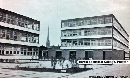
New buildings such as Crystal House, St Georges Shopping Centre, Harris College Technical Building, the New Bus Station and Guild Hall were built.
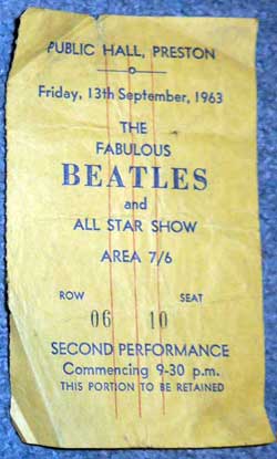
The Beatles in Preston
In October 1962 and September 1963 the Beatles played at the old Public Hall, with a springy floor, which was knocked down in 1989 except for the front which is now the Corn Exchange pub. In 1971 Led Zeppelin played there. My Beatles ticket:
In the 1960s the Harris College was expanded and became a Technical College. The three main buildings those on Corporation Street and the Harris Institute overlooking Avenham Walk which was the Art School. The new building set back from Corporation Street was the technical block and equipped with engineering laboratories which require expensive machinery. Students could study HND full time usually company funded or HNC on a day-release from work basis.
In the 1970's the dock closed for trade and a slow process of redevelopment started. The Electricity Power Station next to the docks closed and was demolished, gas works began to move away from coal to North Sea gas.
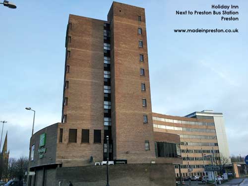
Photo: Holiday Inn, Preston.
In 1972 the Preston Guild had a more popular entertainment theme.
The major rail route was electrified, many branch lines closed, motorways became widespread.
In 1985-6 Preston North End had their worst season ever. Finishing 23rd in the old 4th division and having to be re-elected. It was said Leicester City voted against PNE remaining in the league. Preston were promoted in 1986-7.
1990 - now
In the 1990's the Fishergate Centre opened and the docks took on a new look.
In 1990 the large aircraft factory formerly employing over 4,000 people in Strand Road closed and was demolished.
In 1992 the Guild had morphed again into one with an ethnic slant. Around 5% of the population is classed as ethnic.
Mosques and a Hindu Temple have been built.
University status was given to Preston Polytechnic.
Preston was declared a city at the Millenium and the main church became a minster.
Call centres became major employers.
In the 21st Century Preston is (has) developing into the main regional centre with good rail and road links, quite a good shopping area, reasonable culture with the Harris Art Gallery and Charter Theatre and a large youth culture at the University. Also the area around Winckley Square is smartish with a few decent cafes and there is a good mixture of old and new buildings throughout. In this respect it has done better than most of the nearby towns but there are still the inevitable problem areas. Its proximity to Manchester and Liverpool might be both a hindrance and help in that it isn't a bad commute, bringing in money, but then it is competing against their larger shopping and entertainment facilities.
The area around Preston took a new look from the 1970s as the Central Lancashire New Town slowly filled the fields into the surburbia of South Ribble. New roads and motorways seem to create a spiders web which gets very congested for a few hours around 8am and 5pm every day. Park and Ride systems are in place at most compass points although outside the rush hour I've never experienced any difficulty driving or parking in Preston.
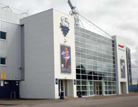
Photo: One of the largest new buildings is the complete rebuilding of Deepdale. The home ground of Preston North End since 1878. Very smart it is too.
In 2009 Crystal House a prominent building next to the Flag Market was re-furbished after 40 years of being the pariah of the centre and now looks fairly decent.
In 2009 Preston Council pursued a plan called the Tithebarn Project to add 2 large stores and other shopping and office space by knocking down the landmark bus station and building a new one near the parish church. The council agreed planning permission in July but other towns in the area are objecting. In 2011 after ministerial approval for Tithebarn, Blackburn decided to take further legal action which they lost.
The Tithebarn Project, Winckley Square refurbishment, Flag Market refurbishment and Riversway are projects promoted by the council. Each one has vociforous objectors and during the post economic crash re-stabilisation period has unlikely prospects.
Would be interesting if Horrocks was around today, he'd get a shock from the planning process. It's a contrast from the 1960's when buildings were knocked down that should have been preserved and new ones built that today look unfortunate, at best. That's the problem of modernity and fashion, it isn't long before you say 'Did I like that?'. We need to be on our guard to keep the best of the old, and more. Although often buildings go through a cycle of fashionable, objectionable, rehabilitation, treasure.
2011 Preston has got quite a few new hotels with another opening recently. The Harris Museum is spending a lot of money re-creating the History of Preston exhibit in time for the Guild. The Tithebarn Project is being re-aligned to a more modest scheme after John Lewis withdrew its flagship store in November 2011.
In 2012 a very successful Preston Guild was held in September. In December the council announced it was planning to demolish the bus station, a huge building which has become an icon and is only 40yrs old.
In 2013 the Bus Station has been Grade II listed. The Cenotaph has been cleaned.
2013
City Deal was introduced by the Government to achieve the growth potential of key cities. The Preston, South Ribble and Lancashire City Deal was signed in September 2013.
?434 million investment will expand transport infrastructure, create 20,000 new jobs and enable over 17,000 new homes in the next ten years.
Central Lancashire is part of the ?23bn Lancashire economy, supporting more than 620,000 jobs in 45,000 businesses.
The Lancashire Enterprise Partnership, Lancashire County Council, Preston City Council, South Ribble Borough Council and Homes England are working together on the City Deal programme, including a ?100m pension investment fund.
2014
In 2014 the Bus Station was bought for ?1 by Lancashire County Council and is to be used as a bus station on the east side and a sports complex developed on the west apron. Also in 2014 the Guild Hall was bought for ?1 by a local businessman and is to be updated. Fishergate has a new pedestrian friendly, modern finish between Lune Street and the Railway Station with plans to further extend it towards Church Street. The Cenotaph was cleaned and its surrounding area improved in time for the 100yrs since the beginning of World War 1 ceremony.
In the north the Broughton interchange with the M55/M6 was improved and a new junction west of Broughton on the M55 and link road to west Preston and BAE Systems at Warton is planned. A large new housing development along the M55 north of Preston is planned.
In the south west area a short new road, just over half a mile, is planned to link the A59 to the existing A582 to divert traffic off the A59 and round Penwortham. It is thought this could be the key to a new Ribble crossing coupling with the new M55 link road.
2015
In 2015 UCLan announced a big reshaping of the Adelphi area including knocking down Fylde House. This ambitious project is well underway in late 2015 and should be a great addition. The old Harris College has turned into a big place with student accommodation taking up big areas.
The Bus Station remodelling has been approved and a design chosen that will use buses on the east side and have a pedestrian area and a new building on the west side.
Improvements for pedestrians are being made all along Fishergate, this also looks very smart.
The area along the west of Stanley Street has been flattened for a new development and plans for improving Church Street are being discussed.
2016
Winckley Square re-opened following an update in November 2016.
2017
In 2017 the University of Central Lancashire, UCLan is building a large Engineering Block just off Adelphi roundabout and has big plans to expand taking over the large Adelphi roundabout now that the Fylde Building has been demolished. The total cost is estimated at ?200m.
A huge expanse of new housing between Lightfoot Lane and the M55 is being built. The Broughton by-pass opened.
2018
Preston was voted the most improved city and 14th out of 42 in the index of best living places by PriceWaterhouseCoopers and Demos.
In 2018 electrification of the line between Manchester and Blackpool is expected to be completed with the line between Preston and Blackpool closed for 4 months to March 2018. The Preston to Blackpool line re-opened in April and the electrification work continues on the Preston, Bolton, Manchester line with a forecast completion of December 2018.
In June the Bus Station and car park re-modelling was completed with buses limited to the east side and a new coach area. The planned Youth Zone on the west side was scrapped due to lack of funds.
Work on Fishergate making it more pedestrian friendly and tree lined was completed.
The prominent former Baptist Church on Fishergate has been refurbished and opened as Bistrot Pierre.
The Guild Hall frontage has been modernised.
Work on the former Post Office Building has begun to create a new central hotel - The Shankly.
Work continues on the large UCLan Engineering Innovation Centre building.
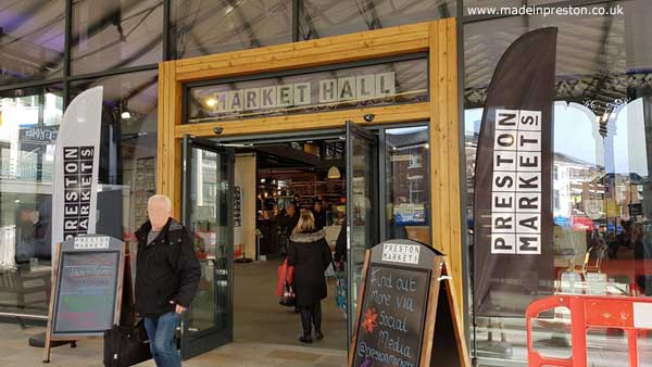
The Victorian Covered Market was re-opened with a glass indoor section and the old Indoor Market closed.
2019
UCLan opened its ?35m state of the art Engineering Innovation Centre in October.
The Guild Hall closed in May 2019 after discussions with a management company were delayed.
Preston's listed brutalist Bus Station was 50 years old in October and a choreographed bus routine was performed to music on the apron. The Harris held an exhibition to commemorate the anniversary.
Work continues on the former Post Office Building to create a new central hotel - The Shankly.
Work commenced October on the M55 to Blackpool Road link.
The Penwortham by-pass opened in December.
In December Virgin Trains ceased to be franchise holder of the West Coast Main Line after 22 years. Avanti took over on the 8th December.
A new car dealership opened a smart new showroom near the docks in June - Preston Porsche Centre.
2020
2020 was a bad year with a worldwide Pandemic, Covid 19, closing many businesses and forcing people to stay at home. Millions of workers were paid by the government for over a year to prevent businesses folding.
Covid-19 Pandemic
The biggest event in the UK and all over the world for a long time is the Covid-19 pandemic which was first detected in China in late 2019, reaching Europe at a low level in late January 2020.
By late February Italy was experiencing around 100 cases a day reaching 239 on 29th Feb. People returning from winter holidays in Italy were spreading it round Europe.
On 2nd March the UK had 32 cases and the first death(ref Public Health England).
13th March football is halted and travel restrictions are increased. 16th March non-essential travel advisory is issued. 23rd March non-essential activity is stopped, effectively putting the economy on ice for an unknown period.
In Preston, on 22nd March 2020 Preston Hospital recorded its first death, and 10 deaths were recorded in March. 96 more deaths occurred between 1st April and 23rd April and a provisional 18 more up to 28th April. A total up to that date of 124.
The highest number of deaths at Preston Hospital on one day was 11 on 15th April, a very black day. 8 provisional deaths total on 24th April. This is tragic news for many families, great respect and condolences are offered.
29th April work in non-essential areas is still stopped and people unable to distance from work colleagues are working from home or not working. Shops, cafes, entertainment and hospitality venues are closed. DIY stores opened this week. Trains and buses are moving on restricted timetables with almost no passengers. Almost no flights are taking place.
See our Covid 19 in Preston report page
2021
In 2021 vaccinations for Covid 19 got into full swing with over 100 million doses given by November. Hospitalisation and deaths reduced substantially due to vaccination despite a resurgance of cases in mid-year and re-opening of events.
An effect of the Pandemic lockdowns is that people have started working from home and having shopping delivered. Many stores closed and there is debate about whether working from home is the new normal. House prices increased as people sought houses they would like to work from and coupled to a surge of new house building all around the fringes of Preston and many other towns and cities it has caused a shortage of building materials.
As restrictions eased people started spending their money causing shortages, coupled with a worldwide shortage of computer chips and blockages at ports all over the world.
On 27th September 2021 the new student centre opened at the University of Central Lancashire. This includes a transformation of the Adelphi roundabout area. Coupled with the new Engineering and Innovation Building the area has stepped forward 50 years.
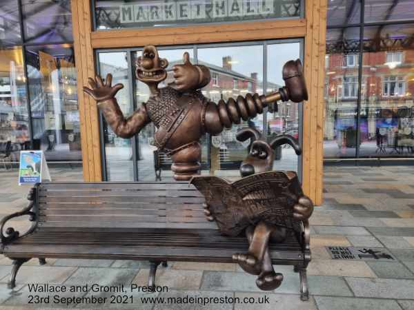
In September a piece of public art was installed outside the New Market Hall, Wallace and Gromit, in celebration of Nick Park their creator who was born in Preston.
2022
2023
2024
Listed Buildings in Preston
Preston has a lot of features listed by English Heritage. These include buildings, railings, lamp-posts and more. The Harris Museum and Art Gallery and St Walburge's are Grade 1 listed.
Arkwright House, Part of UCLan, St George's Church, St Ignatius's Church, St John the Divine Church, St Michael's, St Wilfrid's, St Mark's, The Bull & Royal, The Harris Institute and the Sessions House are Grade II*.
A complete list is contained here.
History Books about Preston
The number of history and heritage books about Preston has increased faster in recent years.
Read our page of Preston Heritage Books click here