
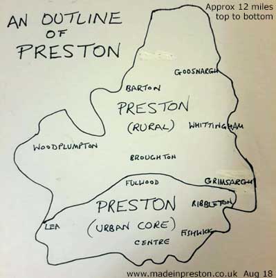
Preston
Click here for a map of the location of PrestonPlease use the menu above to find out more detail.
Preston is located on major converging routes which make it a natural place to meet. As well as being within 15 miles of the geographic centre of Britain.
In the 25 years it has renewed a lot of its infrastructure and the expanding university has added a buzz to the area on the northern edge of the centre.
Preston has many major roads and rail lines passing through or nearby such as the M6, M61, M55, M65 and West Coast Main Line. Direct rail services to London, Birmingham, Manchester, Liverpool, Glasgow, Edinburgh, Blackpool, York, Windermere and Barrow and more. Its bus station was once labelled as the biggest in Europe.
Getting into the centre
Approaching from the south Preston stands above the north side of the valley of the River Ribble which has an attractive mantle of large trees. To the right under 10 miles away are the Pennine Hills stretching into the distance while the view to the left over the Fylde is flat to the sea.
From the M6, onto the A59, pass the Tickled Trout where secret negotiations for top footballers have taken place, that's sounding a bit old now. . Then up the steep valley side through the trees and into Preston.
History
There is evidence in the area of ancient hunters having been at work, the Poulton Elk in the Harris Museum shows signs of an arrow injury, the largest ever Viking silver hoard (Cuerdale) was found just outside the boundary, the Romans had a fort, there is an ancient charter which is celebrated every 20 years in the Preston Guild.
The history of the city includes Roman settlements, a town charter granted by King Henry II in 1179 and battles in the Civil War and Jacobite Rebellion. Jacobite armies camped and fought in the boundary with local support.
Cotton came along and changed the landscape with its pointed, smoking chimneys helping to derive Charles Dickens 'Hard Times' after his visit in 1854. Other industry such as electrical motors, tram manufacturing, aircraft manufacturing, and in neighbouring Leyland, bus, truck, rubber and paint manufacturing made its mark.
Preston is the administrative centre of Lancashire and was given city status at the millenium. It houses the University of Central Lancashire and has a well appointed art gallery and museum, three theatres, attractive parks next to the river and a dockland marina. The Lancaster Canal winds an interesting path north and is now linked to the national canal system via the Millenium Link.
Probably the most famous event is the Preston Guild, held every 20 years or so since 1179, or 'once every Preston Guild' as the saying goes. Every year at Whitsun a fair takes over the city centre although recently it has moved to Moor Park. There used to be religious walks with church banners on Whit Monday until a few years ago with a Catholic walk and a Church of England walk at separate times. Now there is an annual Caribbean Carnival.
The old Harris College on Corporation street and at Avenham became a polytechnic and is now much expanded into the University of Central Lancashire (UCLAN) filling a large and expanding part of the edge of the centre with buildings and student accommodation.
Central Area
Preston has upgraded its central shopping areas in the last few years and has a more modern feel especially around the railway station. There are plans for more improvements. The finest buildings are old ones; Harris Museum, Miller Arcade, Parish Church (now Minster), St Walburg's, Winckley Square, Miller Park.
1960/70's buildings include the Guild Hall, Bus Station, Market Hall, St Georges Shopping Centre, Crystal House . In the last few years the old dockland has been re-developed and is now very 2000ish. The Deepdale Retail Centre near the football ground is popular.
There are several interesting parks, the best in my opinion, are Miller and Avenham. Although Moor, Ashton and Haslam are extensive.
Recently in 2024 we've added a series of walks to the blog: Here are a couple of them.
A walk to UCLan Preston in summer 23rd July 2024 Including the Tom Finney mural.
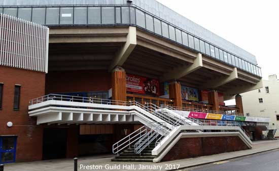
There are 3 theatres, the Guild Hall contains 2; the arena and Charter Theatre (note the Guild Hall is currently closed) and there is the Playhouse Theatre. Cinemas are on the docks and at the Capital Centre in Walton Le Dale. There are a number of clubs and these tend to rotate round the student population as does the number of comedians who visit.
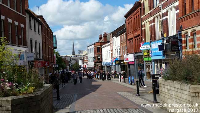
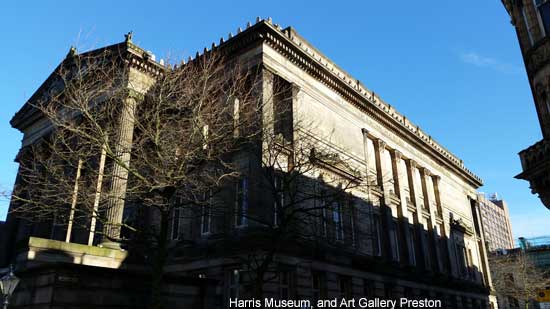
The best built view in Preston is up Friargate to the Harris building which contains a museum, art gallery and library. The museum has a display of the history of Preston with dug out canoes found in the river through to industrial times and Horrocks' factories. It also has fine art, an excellent dress and glass collection and periodic special displays and events. (the Harris is closed for refurbishment until 2025).
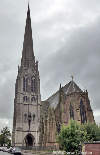
Another iconic view in Preston is St Walburge's church steeple next to the railway line which is beautifully formed and coloured.
The ornamental Miller Park is next to the river and railway line. With its neighbour Avenham Park, a natural amphitheatre, the river bridges and Avenham Walk are an attractive feature.
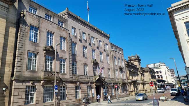
Photos of Preston Town Hall.
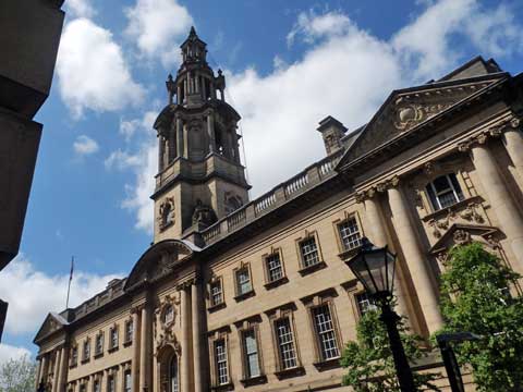
The main entrance to Preston Town Hall:
Surrounding Area
In the surrounding area is lush and green farmland, such as the Ribble Valley, West Lancashire Plain and the Fylde, where as a bonus tasty creamy or crumbly Lancashire Cheese is made. The surrounding villages have their own story. This farmlife continued while from around 1800 to 1880 Preston grew from an agriculturally based economy of about 10,000 people into an industrial town of over 100,000 people, mainly based on cotton but also on engineering..
Manufacturing History & Employment
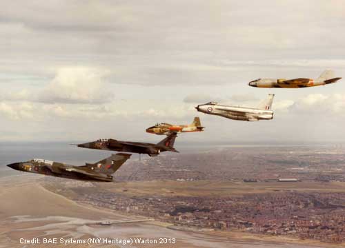
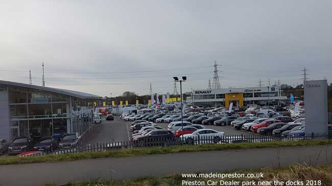
World class engineering products have been designed and made in Preston and its surrounding area including Leyland. There are many military aircraft types such as the Canberra, Lightning, Tornado and Eurofighter Typhoon. At Leyland there is the Atlantean bus design and a long history of buses and trucks as well as paint and rubber. There are the English Electric trams and the Deltic locomotive prototype. Large manufacturing companies now include BAE�SYSTEMS�and Paccar (Leyland Trucks). These are the former English Electric Aviation and Leyland Motors. Cotton has left its mark but no longer employs a significant number, if any. The name Horrocks achieved fame through its finished products and womenswear: Horrockses Fashions. Alstom on Strand Road is the last remnant in the actual boundary of Preston of Dick Kerrs / English Electric / GEC Traction. The docks have closed to the shipping trade and are now a marina, shopping and apartment area.
Employment has certainly changed as with most places in the UK. A lot of government jobs with the Lancashire County Hall, City Council, Education such as the University of Central Lancashire and the large hospital. In surrounding areas the Premium Bond office is in Blackpool, Land Registry near Lytham. Call centre work with Carphone Warehouse opening a large, 800 employee office to complement existing ones related to mail order and travel, Netflights. Engineering companies - BAE SYSTEMS aircraft design and manufacture and Paccar Trucks assembly are major employers in the area. BAXI heating started in Bamber Bridge, 140yrs ago, just south and still has a factory there. Beech's chocolates have been made for 90 years. Liquid Plastics is prominent from the main road.
Football & Sport
The main local football team, Preston North End, is currently in The Championship and has a long history of achievement including being a founding member of the football league, double winners and twice cup-winners.
Preston Grasshoppers Rugby Union Football Club is the main rugby team.
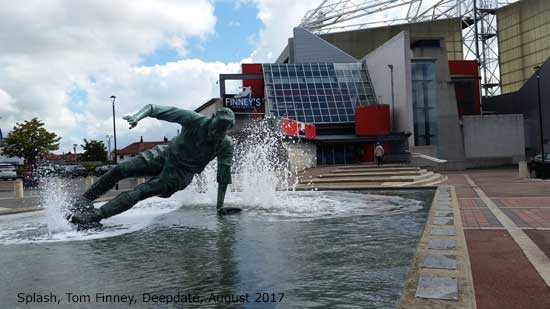
The National Football Museum was in Preston until 2010. 'Splash' the statue of Tom Finney.
The famous Dick Kerrs ladies football team was also from Preston. There are dozens of minor football and cricket teams filling a close typed page of results in the local paper. Within 30 miles is the best football in Europe - Man U, Liverpool, Man C, Everton, Burnley. Bolton, Blackburn, Wigan, Blackpool, Fleetwood. There are several sports facilities.
A fairly new club, AFC Fylde, has a new ground near Kirkham and has moved up into the National League.
Transport Links & Regional Attractions
Located above the Ribble valley flood plain. Preston is well linked, being next to the M6 and on the London to Glasgow West Coast Main Line. It is 30 - 40 minutes drive or train to the great cities of Manchester and Liverpool and the major leisure locations of Blackpool, the Lake District and the Yorkshire Dales, not to forget Southport. The Lancaster Canal has recently been expanded to link it to the River Ribble and onto the national canal system. Preston could be said to be the boundary between the built up lower section of England and the less densely populated north of the UK. You can soon be either in remote country, a large centre like Manchester, a more gentile Lytham St.Annes or on Blackpool promenade. It is also geographically almost in the centre of Great Britain.
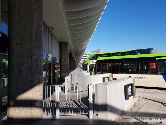
Transport links are via the M6 Junction 31 for central Preston, and Deepdale, and if you are going to the M61 / M65. Junction 32 for the M55 and north. The bus station was said to be the largest in Europe and has an unusual island design. Originally with, corporation buses on one side, regional/national on the other, with what I think is Oriental styling for the car park above.
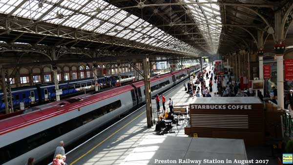
The largish railway station is at the opposite end of the central area to the bus station and is set back from Fishergate with access through the Fishergate Shopping Centre. Outside rush hour the roads in Preston are usually pretty easy although traffic-light mania sets in along Blackpool Road, the A5085, and I wouldn't recommend it at any time as a through route. If you're going to Deepdale from the motorway you miss most of it.
Nature
The Lancashire Wildlife Trust has a new and award winning reserve at Brockholes next to the River Ribble and accessed on the A59 at the M6 J31 roundabout. The Ribble estuary is a major bird area with RSPB Martin Mere about 10 miles south west of Preston. There's another nature reserve at Cuerdale, south of Bamber Bridge on the A49. Also Martin Mere RSPB centre to the south west. The River Ribble has a large estuary and Morecambe Bay is a famous for its huge areas of sand which can be dangerous..
People
Around 140,000 people live in Preston. South Ribble, across the River Ribble, has another 100,000.
Preston has a higher number of Roman Catholics than most places although maybe that has no real significance today.
It is possible to detect differences in local accents. If you're a connoisseur of accents it's great fun to detect the subtle differences of Preston, Blackpool, Blackburn, Bolton, Wigan, Liverpool and how they're mixed in the surrounding areas. Maybe less so now as people move about more and the influence of broadcasting.
Media
The local paper is the Lancashire Post Local radio is BBC Radio Lancashire and Preston FM. That's Lancashire is a local TV station with good news content and presenters, Channel 7 or 107 and on YouTube. Blog Preston is a useful news site. Lancs Live on Facebook.
Preston's twin towns
The making of European links via Twinning began in Preston 1948 with Almelo in the Netherlands. This grew to include Nimes, France in 1955, Recklinghausen, Germany in 1956 and finally Kalisz, Poland in 1989.
Favourite Buildings
The Preston Top Ten of interesting buildings and places. The writers opinion. Many more are English Heritage listed buildings.
1. Harris Museum and Art Gallery (Grade 1 listed)
2. St Walburge's Church (Grade 1 listed)
3. Miller and Avenham Park and Tram Road
4. Miller Arcade (Grade 2 listed)
5. Preston North End, Deepdale.
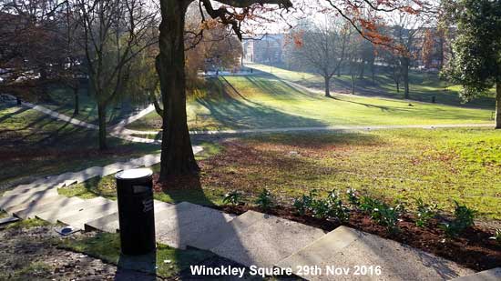
6. Winckley Square area
7. Bus Station (Grade 2 listed)
8. Preston Docklands, Albert Edward Dock
9. Friargate, view up to the Harris and the upper stories of the buildings
10. Fulwood Barracks, which also contains the Lancashire Infantry Museum. (Grade 2 listed)
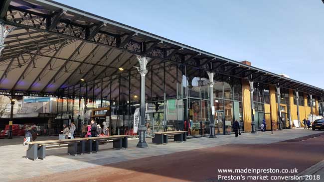
Other notables: Victorian Covered market, one of the biggest of its type. Guild Hall should have been great but isn't.
Special mention to the British Commercial Vehicle Museum at Leyland. A personal favourite is the Museum of Lancashire in Stanley Street, Preston.
Latest and Future
Preston has a number of grand plans. Some of them are hamstrung by divergent opinion and / or funding but over the last few years several have been completed.
The University of Central Lancashire, UCLan built a large Engineering Block just off Adelphi roundabout and very recently opened the Student Building next door. See our walk in the area on our blog:
A walk to UCLan Preston in summer 23rd July 2024 Including the Tom Finney mural.
In late 2012 the council trimmed the sails of the city blaming reduced budgets although long term neglect seems to be another contributor. The car park next to the Covered Market has been knocked down and a new building is being constructed. . The large covered market has now got glass walls and things are moving on the old covered market.
The old Post Office Building across from the Harris was to be a boutique hotel named originally The Harris Hotel but this has been changed to The Shankly Hotel and now its future is uncertain...
Winckley Square is an attractive Georgian sunken garden just off the main shopping street and was re-opened following an update in November 2016. A pleasing area.
House Building
Big new sites especially next to the M55 from Fulwood to Bartle. This area is known as Preston Rural but not for much longer although it does extend much further north which hopefully won't all be built on. In 2024 house building is well progressed with many houses next to the M55 and a new access road built.
Railway Electrification
The line between Manchester and Blackpool was electrified by 20th May 2018. New rail stock was purchased.
Road Upgrades
The Broughton by-pass opened in October 2017 to improve the A6 from the M55 roundabout to just beyond Broughton.
The Western Distributor, A583, opened on the 3rd July 2023, to create a dual carriageway from the M55 south towards the A585, Lea, Preston Dock, Warton and Lytham.
Plus a Penwortham by-pass by routing the A59 round its border.
Plans on Hold (needs update):
Tithebarn was a major shopping and office development to be built on the site of the current bus station and surrounding area. An inquiry took place between May and July 2010 where Blackpool and Blackburn councils objected that it is an excessive development detracting from them and Preston hasn't enough high earners to sustain the shops. The government threw out the objection but Blackburn continued with further action till it was over-ruled. The delays and recession caused the plan to be cancelled along with the bus station being granted Grade II listing. The bus station was taken over by Lancashire County Council who sold it for a penny and it is being refurbished.
The Flag Market is the main historic meeting place of Preston with the best built view up Friargate to the Harris building. The council has a plan to cut down the trees and erect flag poles round the square giving 'flag' market a whole new meaning. Quite a lot of head scratching questioning what this is about and it hasn't happened.
River Project. This has gone quiet. A plan to dam the river to create a lake effect and promenade and to develop the flood plain with shops and offices. The view out from Avenham Park into the country would be changed into another shopping area. Not to mention whether the river will flood more in future. Let's hope this never happens.
Another project being debated is building a tram / light railway network linking initially the next to the M6 Park and Ride Car Park and the City Centre via the Deepdale Shopping Centre. Some of this will be built on disused railway track which goes through a tunnel. It seems to have some traction as a social and environmental project. This sparks then fades, whether it will ever take off is open to question.
Choose further reading from the site map
A short essay about Preston written by Desiree Le Claire of Reutlingen (near Stuttgart) written as a school project. 14th Jan 2013. (Please note we cannot vouch for the content but it is a good piece of research and language study and an example of how students overseas learn English so well). A bit of feedback: Desiree says her teacher commented it is too much like a list, but she is happy with her mark.